


By: Kate Kimmel
Nassau County has taken several steps over the past year toward protecting land along the St. Marys River, elevating the river corridor as one of the county’s top conservation priorities heading into 2026.
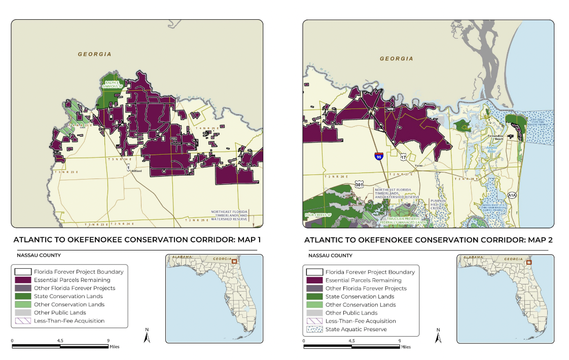
Those efforts include both a land acquisition and a conservation easement that have advanced the Atlantic to Okefenokee, or A20, conservation project — a partnership between the county, the Florida Department of Environmental Protection and regional land trusts aimed at preserving a continuous corridor of land stretching from northern Amelia Island along the St. Marys River to the Okefenokee Swamp.
The Conservation Land Acquisition and Management Committee identified land along the St. Marys River as a top 10 priority for 2026, citing the river’s environmental value and its role in protecting water quality, wildlife habitat and floodplains in northern Nassau County.
According to the St. Johns River Water Management District, the St. Marys River is used for agriculture, as a drinking water source, and provides habitat for a variety of wildlife, including at least two rare species and the endangered Atlantic sturgeon. The river also serves as a natural floodplain, helping to reduce storm-related flooding and damage in surrounding areas.
While recent reports show overall water quality in the river remains good, some areas have experienced degradation. Alligator Creek, a tributary of the St. Marys River, has been impacted by discharges from wastewater treatment plants. Officials have identified secondary effects of development — including chemical and pesticide runoff from lawns and roadways, as well as leaking septic systems — as the greatest long-term threat to the river’s health.
As the county faces large projected population growth and increasing private development, the A20 project seeks to address those risks by preserving land along the river corridor before development pressures intensify. A partnership between the county and the North Florida Land Trust aims to conserve approximately 55,865 acres within the A20 corridor. The project was included on the state’s 2025 Florida Forever Priority List, making it eligible for state conservation funding.
According to the Florida Forever plan, properties within the A20 corridor are held by multiple owners, with about 38,844 acres, roughly 70% of the proposed conservation area, owned by Rayonier Forest Resources or its real estate subsidiary, Raydient LLC. The plan anticipates a mix of fee-simple purchases and conservation easements to achieve long-term protection.
Over the past year, Nassau County has placed 734 acres of river adjacent land into conservation through a combination of acquisition and easement agreements, marking early progress toward the broader A20 goal.
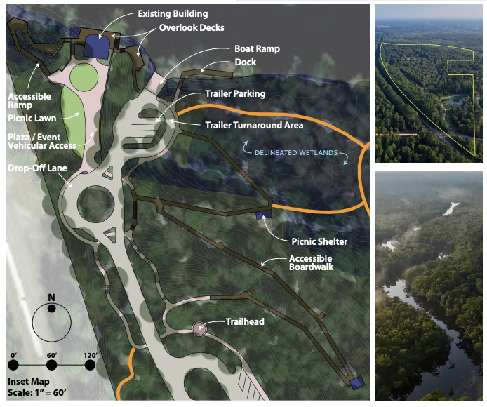
The most recent acquisition was a 134-acre property along the St. Marys River corridor near Hilliard, formerly used as an event venue known as Callie’s on the River. Purchased for $2.42 million through the county’s Conservation Land Acquisition and Management program, the property includes approximately 29 acres of wetlands, 109 acres of uplands and about 3,500 linear feet of river frontage.
County plans for the site include designating about 61 acres for conservation land, 42 acres for vendor uses yet to be determined, and 25 acres for roads, parking and public day-use areas. Existing features on the property include a clubhouse, studio cabin, horse barn and trail system.
The county also intends to expand amenities at the site to include a boat access point, pavilion and playground. Any future vendor uses would align with the property’s passive recreational purpose, such as RV parking or camping, Communications Manager Gary Davis said.
In addition to the land purchase, the county entered into a conservation easement with the owners of St. Marys River Ranch, preventing development on a 600-acre riverfront portion of the 648-acre property. The county paid $2.1 million for the easement, representing the appraised value of the development rights extinguished by the agreement.
Unlike a land acquisition, the easement leaves the property in private ownership but restricts future development on the protected acreage. County staff are authorized to conduct inspections on an as-needed basis to ensure compliance with the easement terms. The remaining acreage not covered by the easement may still be developed.
County staff will have approximately one year to develop management plans for both the acquired property and the easement area, outlining conservation practices, public access and long-term maintenance.
Additional acquisitions along the river may follow. In December, the CLAM Committee ranked a project called “New West St. Marys River” as its seventh-highest priority. The project would involve the potential acquisition of two properties with river frontage on the county’s western end totaling approximately 821 acres.
County commissioners and CLAM committee members have said that the recent deals represent significant progress toward protecting the St. Marys River corridor. The establishment of the A20 project was marked as a “fearless target” in the County’s strategic plan adopted in 2022, and the progression of the project moves the County closer to achieving its long-term environmental resiliency goals.
